
This past summer, Val Myers and his adventure partner, Kyle Sprenger, set their sights on the Bagley Icefield, an endless expanse of ice that sprawls across our backyard and stands as the second largest icefield outside the polar regions. Their plan was ambitious: a traverse linking hiking, skiing, and packrafting into one continuous line all the way to Yakutat. We were lucky to support them where we could, offering air support, a few aerial perspectives, and some local connections along the way. Even so, the landscape reminded everyone who was really in charge. What follows is just a fragment of their story here, but the full account on Val’s blog is well worth your time. These two move through the mountains with intention and curiosity, and if history is any guide, this won’t be their last line through the Wrangells!
BITE25: The One Where Everything Went
Written by Jacob “Val” Myers
First Glimpse
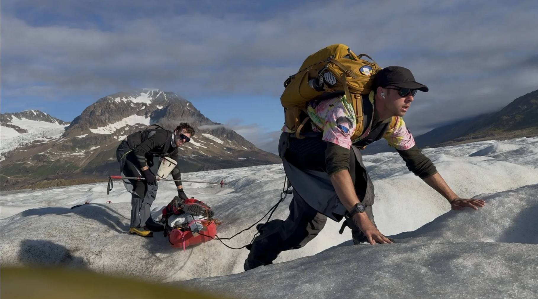
The plan seemed difficult to execute on, but the route itself wasn’t terribly hard to fathom. Kyle and I would land at the Avalanche Lake airstrip, which in reality was just a stunning mound of glacial kame, and then pick our way through the valley to the lake itself. Avalanche Lake is ephemeral, meaning it only exists for part of the year. Lakes like this rely on snowmelt and glacial rivers to keep them full, and as the snow recedes throughout the year the body of the lake dives into a deep decline. This was the part of the year where it would be reduced to silt, meaning we could walk right through the center of the basin to access the glacier. Once on the glacier, we would crampon our way to the firn line, the line of snow that remains permanent each year. This marks the elevation at which we would begin our switch onto skis before traversing the Bagley Ice Field all the way to the outflow where we would finally pump up our rafts and paddle to the remote fishing village of Yakutat.
Kyle and I had been combing over this project for a solid six months, and in the flurry of logistics, training, and enjoying the village it never really felt real until we saw our objective from the sky. A couple vertical miles up in the sky is a premiere vantage to appreciate the scale of the mountains ahead. Mt. St. Elias and Mt. Logan were both feared and respected vistas in the community. The near sheer walls of snow and ice hid ancient crevasses and were magnets for extreme weather. In a brief conversation with esteemed mountaineer, Conrad Anker, he told me to prepare for more rain than snow. Duly noted.
Through aviator headphones the world became silent for all but the brief conversation between us and our pilot. The number of folks in the village who had caught wind of what we were attempting came as a bit of a shock to the two of us. “I almost felt more confident when no one cared,” Kyle chuffed as we soared over some mountain goats. I felt the sentiment too, like we were missing something huge here. There was a certain amount of acceptance for navigating the unknowns, and we were both immensely capable of doing so. We knew that about ourselves. The question for months had been “what are we missing?” Grizzly Bears? Avalanches? Crevassing? Whitewater? Evacuation Routes? Surface Strata? We dug and dug and dug, even paying a pilot beforehand to photograph the glacier from the sky so we could assess current conditions. We were content with the work that had been done.
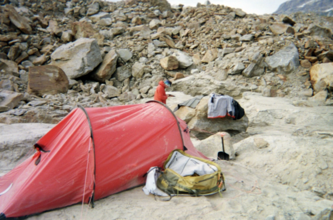
We came rumbling across the soft landing pad with our backs to the Tana before deboarding, shaking the pilot’s hand, and then waving with excitement as he disappeared around the bottom horseshoe’d prong of the mountains that encompassed us. Night zero was meant to set the mind right, and so we pitched camp immediately, noting the grizzly prints in the sand as we crossed the landing strip, and then picked our way up one of the burrels to a small icefall beside camp to watch the sunset. It was nearly eleven at night before night finished falling.
The Journey
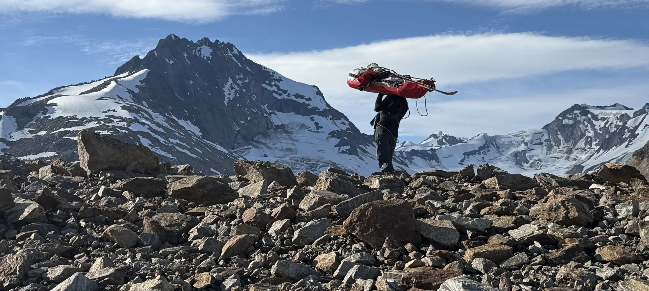
We were thrust into the thick of it immediately. With about seventy-five pounds tied to our backs and another seventy or so in each man’s pulk behind us. The tall grass concealed trashcan-sized boulders and deep, muddy rivulets that made the hauling slow and difficult. By only the second mile a sharp rock had caught one of the guylines on my pulk and cut it in half, unraveling the load I had tied down and weakening the structural integrity of the entire system. I patched it with square knots and paracord, but it was apparent that until we reached snow this would be an ongoing challenge. By mile three we opted to porter the pulks one at a time on our backs until we could step onto ice and begin reliably hauling the system behind us. Across hidden mud holes that sank us to our knees and over a ridgeline that required both men to move each bag (requiring four total ascents for the four gear bags) by “rowing” them uphill. We slang the bag, still strapped into the pulk, uphill with a great heave and then each moved our feet two steps to a stable position, ensuring with great care not to rip one of the giant boulders off the hillside. Sometimes we did anyways, but we made sure to remain lateral of the other bags to prevent a loose rock from flying down and destroying our equipment.
We read trip reports on this region and scouted satellite imagery to confirm the passability of the lake as well as its ephemeral nature — but if there is one thing I have learned about a life in the outdoors, it is that environments are quite dynamic. Once Kyle and I finally crested over the hill we saw not a divot of sand to cross but a seventy-foot deep pool of water with icebergs the size of cars floating all over the surface. It seems massive pieces of ice calved off the face of the glacier and plugged up the outlet where the water traditionally flows, effectively creating a dam. To make the situation more tricky, not only could we no longer walk along the flanks of the lake bed with our pulks, but the afternoon sun had melted enough ice off the surface of of the glacier that the rivulets which feed iceberg lake had risen by multiple feet. The crossing was simply too dangerous, so we relegated ourselves to a cold swim in the lake and an early bedtime while small buildings worth of ice flew off the top of the glacier all night. Somewhere within the cold, short Alaskan Summer night the ice ceased its melt, the glacier ceased its calving, and by first light the next morning we were equipped to make our swim across the river.
You can finish reading the rest of Val and Kyle’s story on Val’s blog. Val and Kyle are professional guides seeking to accomplish feats in the outdoors that no one has done before, and Wrangell St. Elias is an excellent place to do that, but it also is a phenomenal place to experience previously established routes with a guide service or on your own! So if their expedition got you interested in planning a trip, find out more about our backcountry landing strips on our backcountry page.
Ready to Fly Over Wrangell-St. Elias National Park?
With over 30 years of safe, unforgettable journeys, our experienced pilots are your trusted guides to America’s largest national park. Experience the unparalleled beauty of Wrangell St.-Elias National Park with Wrangell Mountain Air. From flightseeing tours to backcountry adventures, we’ll fly you to Alaska’s most remote and stunning destinations. We make wilderness accessible!
Book your flight today and let the adventure begin!